

Helene is on track to make landfall on Florida’s Gulf Coast — likely in the Big Bend region — late Thursday. It could be a Category 3 major hurricane when it reaches the coast, strengthened considerably by the extremely warm water of the Gulf of Mexico. Rapidly intensifying storms like Helene are becoming more frequent in a world warming due to fossil fuel pollution.
Coastal areas typically bear the brunt of a hurricane, but that might not be the case with Helene.
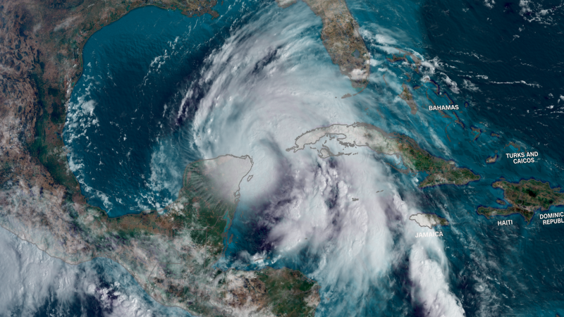
Tropical alerts span hundreds of miles from South Florida to central Georgia and southern South Carolina because of its size.
Hurricanes typically lose strength quickly once they move over land, where they lose the warm water that feeds them, but Helene will remain more intact well inland because it will be both strong at landfall and moving quickly.
As a result, the storm is forecast to still be a hurricane in Georgia Friday morning, nearly 150 miles from where it makes landfall.
The storm’s damaging winds will spread outward hundreds of miles from its center and increase the risk of power outages and flooding, torrential rain well inland starting late Wednesday even before the hurricane’s center comes ashore.
By Thursday evening, tropical storm-force winds will spread over more of the Southeast and, along with soaking rainfall, could bring down trees and trigger widespread power outages. Atlanta could have wind gusts of 30 to 40 mph during the day Thursday that strengthen to 50 to 60 mph overnight.
Helene could produce historic flooding in mountainous areas of the Southeast far removed from the coast. Flooding caused by rainfall has become the deadliest threat of tropical systems in the last decade.
The storm will combine with heavy rain ahead of it Wednesday to raise concerns of “widespread impactful flooding” including “potentially life-threatening flash and urban flooding,” the Weather Prediction Center warned Wednesday.
A level 3 of 4 risk of flooding rainfall is in place Thursday for portions of Florida and Georgia – including Atlanta – Alabama and the Carolinas. A rare level 4 of 4 high risk encompasses a smaller area from northeastern Georgia to the far western Carolinas, where more than a foot of rain could fall through Friday.
No problem. I want to make sure people know to stay safe. Hurricanes are going to be so much worse than they used to be and I don’t think people are as aware of that as they should be.
We rode out Katrina near the Mississippi Gulf Coast back in 2005, in a run down trailer made in 1979. We didn’t board up the windows, matter of fact we did exactly the opposite.
We opened all the windows and doors, to allow the air pressure changes easier to try to equalize. We sat in the living room, no power, just a battery powered radio, watching the walls ‘breathe’, if you will…
Scary shit yo, but our beater trailer survived. About 45 minutes after the strong winds started to settle down, suddenly the water level raised about a foot and a half, only a couple inches from coming in our front door. Luckily we were on high enough ground that we didn’t get water in the trailer. Luckily.
We were two weeks without power, but at least my dad was smart enough to be prepared with a 400 gallon tank of chlorinated ground water. People though he was crazy for having that much treated water prepared, until Katrina hit, then he was sharing the water with all the neighbors.
TL;DR - Stay safe out there, and prepare early.